Let's start with some new things I've learned ...
- 12 to 13 months is not enough time to see all the things I'd like to see. Several days ago I decided to look at the calendar, figure out what day it was, and where I was in my extremely rough timeline. I'm behind! I guess I had no idea how much there is to see in Mexico and unfortunately, I'm going to have to miss quite a few places I'd like to visit (same goes for the next 5 countries).
- When in doubt, just turn on your emergency flashers. They seem to apply to pretty much any road situation to alert others that something isn't normal (whatever that is here). I've adopted using mine a lot too. It's a good "get out of jail free" card. Just turn them on, do whatever you want and no one will fault you because you had your flashers on.
- While travel is nice, it is nice to move into an AirBnB for a few nights to remind yourself what a normal existence may feel like. Yes, I even finally loaded a VPN on the laptop so I can watch some TV on Xfinity & Netflix. I even watched the debates, but I've sworn myself to not discuss politics on any posts (may get difficult as time goes on).


- More of a re-learn, this isn't all about pretty waterfalls and kindness of strangers (which still amazes me). I still need to keep my house moving down the road.
- The high elevation super windy roads and constant topes plays havoc on my 6.0 PSD engine. For weeks it was all accelerate / brake, accelerate / brake, accelerate / brake, ..... This manages to gunk up the turbo, I belch black smoke on acceleration, and accelerate poorly. Luckily a day of running it hard at speed on toll roads blew all the gunk out and now here at sea level it is happy again!
- I'm now camped out in my AirBnB while my roof is re-fiberglassed by Francisco (Pancho) and his gang. While the AirBnB is a nice break, I'm super stressed leaving my house in a somewhat shady looking spot for them to work on. I'll check up on it a few times a day though. Really curious what color it is going to end up!
- Oh, and I pulled into camp the other day and the refrigerator door fell off. At least it waited until I parked!
- ... and the list goes on.
I'm sure there is more in the new learned list, but let's go on.
First a quick video of my morning view of Guanajuato when I was camped there. It really was a pretty city (as cities go).
My last post was a video about Las Pozas. A cool and bizarre spot. I think (honestly, I'm losing track of when I was where) right before Las Pozas I was at Puente de Dios. This is a cenote which generically (for me anyway) is an opened sink hole from an underground river. This one was fed from an above ground river soooo, you tell me??? Anyway, I made quick friends with a couple from Guanajauto (a beautiful and colorful city I think I posted about on IG / FB) and had a fun afternoon swimming in the blue pools. This is the first time swimming for me on this trip as my thumb wound is finally closed!!


From there, I jumped over to
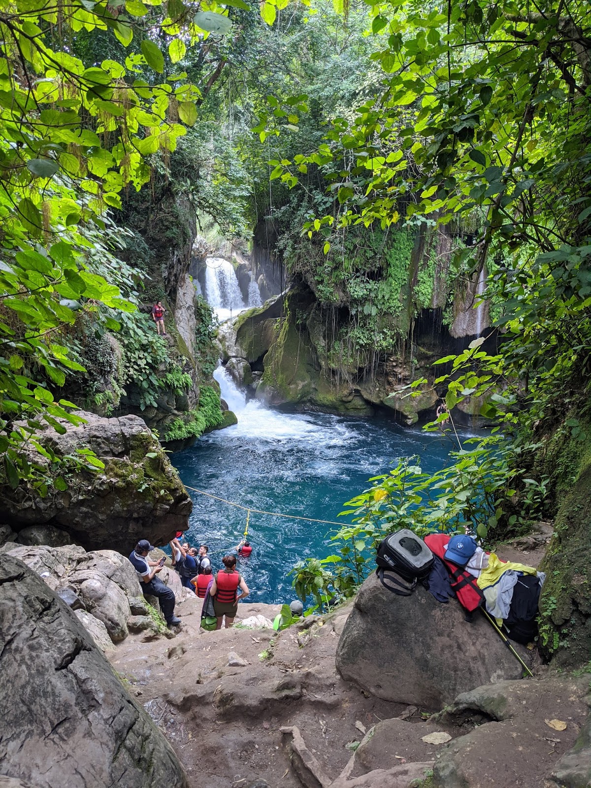
Grutas Tolantongo. WOW, just WOW. The day spent there was certainly near the top of my list so far. It is deep in a canyon down an extremely windy road. The turquoise blue water originates in a cave that you can go in. Didn't realize I should have brought my waterproof light. It is like a super steamy sauna in the pitch black with massive volume of warm water rushing by that you are standing in. After that, we (
I was a 3rd wheel again with my new friends Lot and Ulrich (IG: ven.ritchie) for a day) moved to the big cave under the upper one. This was very large with many nooks and crannies to explore. After a lot of soaking, we grabbed lunch and headed to the warm spring pools built on the side of the mountain and soaked the afternoon away. And to top it off, I was able to camp right on the edge of the warm river where they have made manmade cascading pools. Simply a wonderful day!


A wolf spider that I found by my flip-flopped foot the night I camped by the river. Joan advises I should wear shoes.
Our camp after a long day in the water up on the canyon edge sharing tequila, wine, and Gordon's special Dutch treats (which Lot and Ulrich knew immediately).
After Grutas Tolantongo, it was off to see the ancient city of
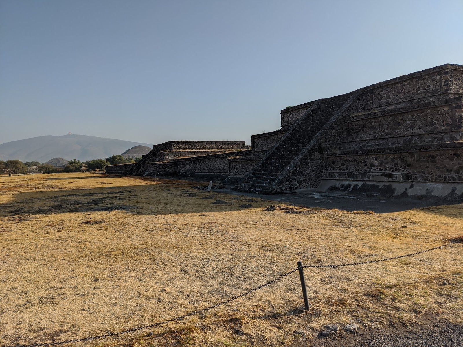
Teotihuacan very near Mexico City. I spent the night within a short walk of the entrance in a field next to a restaurant. The owner liked talking to travelers like myself that come through in the hopes of doing something similar some day. It was a long morning of walking around and climbing, but interesting.


It was now time to go see the
Monarch Butterfly Sanctuary where millions of monarch butterflies migrate to from Canada every year. First, I didn't know butterflies migrated and second, that's a long way to flutter along! After about a 30-45 minute hike up a mountain at over 10,000' I found myself by myself in the middle of these large "pods" of sleeping butterflies hanging from the trees all around me. A worker in the sanctuary came rushing up to me saying something in Spanish (yes, I still need to get more proficient in Spanish!). Long story short, I was where I wasn't supposed to be but he said I could quickly take pictures then move back to the observation area behind the imaginary line. As it turns out, the butterflies needs the warmth of the sun to wake up and start "swarming" around you. Unfortunately, this turned out to be a cool somewhat overcast day, so it was a bit of a bust. They escorted us through the center of the hanging pods to where some were warmed enough to be flying, but then it was back down the mountain. I decided to move on instead of hanging out another day in the hopes the sun would come out. I got the general idea of it though.

I had the entire parking lot to myself to camp in with a beautiful sunset view.


From there, it was time to keep moving up in elevation. I spent the night sleeping at over 13,000' near the top of dormant
volcano Nevado de Toluca in a very isolated area. The wind howled all night and into the morning. Once the sun hit the van I packed up to go up to the trailhead. Once I made my way to the main road up, I realized that the mountain was already very active with visitors. Everyone (except me apparently) parks at the bottom and gets in the back of a shuttle pickup with a canvas cover to make the very bumpy and dusty way up the volcano. When I got near the parking area there must have been a hundred of these shuttle trucks lining the road. Everyone kept waving me through further up until I got to the main lot (a very small parking lot) where some police waved me to a parking spot. And there you have it, I was able to drive through swarms of day hikers to my personal spot right at the trail head! (Another item for the learned list, don't go to popular places on weekends). The hiking was mostly all over 14,000' maxing out for me at 14,756'. My lungs and legs were spent by the end of the day. I have a lot of conditioning to do before Patagonia!


It was around this time I decided to look at the calendar and realize I have to get moving. I had wanted to camp between the dormant volcano Iztaccihuatl and the somewhat active volcano Popocatépetl but that would have chewed up another couple days and took me above 15,000'. My body (and van) was telling me to get back to sea level so I started in the direction of Veracruz having identified a fiberglass boat builder / repair guy in the town of Tlacotalpan who I wanted to see if he could re-fiberglass my roof. For the couple days I was in view of Mt. Popocatépetl it was letting off some energy. Kind of cool to see but certainly added to the poor air quality in the area.

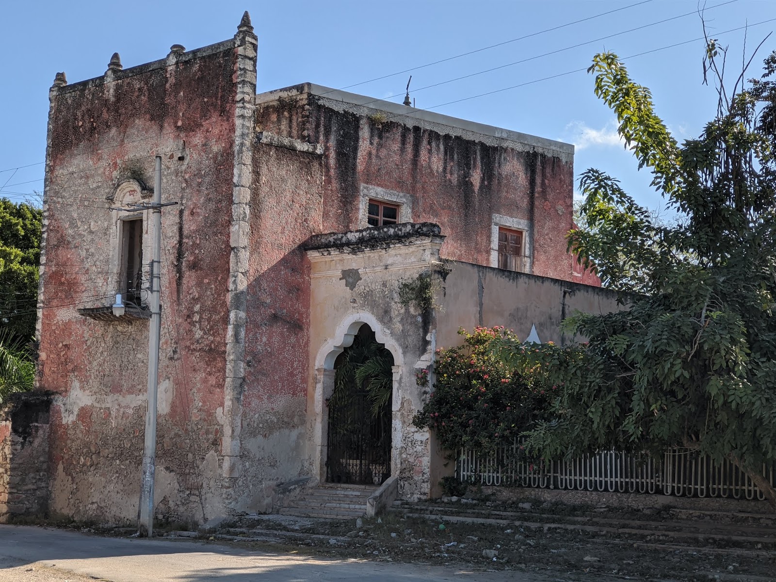
I had another "trust in the kindness of strangers" moment when familia de Contreras accepted the gringo in the big van with open arms. Senior Contreras (Maximo) insisted I park the van right in front of his house next to the kitchen / eating building. I shared a couple beers with one of his daughters and they graciously invited me in for dinner (unfortunately I was just getting hit with a bought of Montezuma's revenge, so wasn't particularly hungry). One of his sons lives in Chicago and knows english which helped out. Maximo is suffering from some stomach issues and was in pain. I felt very bad for him, but it didn't stop him from extending every courtesy to me. In the morning he and I just sat and shared some sort of herbal tea (not sure what it was, but it was good and made my stomach feel better) then hot chocolate / bread (unfortunately, hot chocolate isn't what I needed). There were 4 generations of family living in this compound. In the evening the kids loved exploring the inside of the van and dancing to music I put on. In a little over 12 hours I felt very close to this family and was, again, sad to leave them. I wish the best for you mi amigo, Maximo.


From there straight to Tlacotalpan and started my negotiations with Francisco (Pancho) on re-fiberglassing my roof. Francisco is somewhat of a character. His original price was about $300-$400 higher than I was expecting. I nocked him down a couple hundred bucks when it started raining and I began to stress about water intrusion again, so he had a deal at 12,000 pesos. Then came a little price creep over items that were not included. Assuming they do a good job I'll be OK with it as it will be one less thing to worry about as I head more into tropical / jungle regions.
First camp back at the coast. What a difference from the high elevation I've been at for a few weeks.
Francisco's (Pancho) boats. Wood core fiberglass, just like the roof of my van!
I left my van with this crew. Good guys, but I was still stressed as it is my HOME.
This is my form of a receipt. Whenever I give them money I take a picture of them holding it.
Sanded down to original fiberglass.
3-layers of new fiberglass down and time to sand. I'll probably do a IG post on the finished product when I leave town.
From here, I need to make good time. I'll try to be in Belize within a week of leaving here and after looking around the Yucatan Peninsula a bit. I've been to Belize before so will mostly just see an old friend and a new friend from the Sportsmobile Forum. Then I'll get into Guatemala and see what I can see before rushing down to Costa Rica in time to pick up my wife and my old college roommate and his wife.
For those of you interested in
Tlacotalpan, I scanned the text from a pamphlet a city tourism guy gave me below (this is a text scan from my phone and I have not proofed it). I'm also including a lot of photos from around this very colorful town. It has a very colonial / Caribbean feel (to me anyway).
Still not really sure exactly what this is, but it is really GOOD. Sort of like ice cream, but not. I like strawberry / mango mix!


Tlacotalpan is a town and municipality in the southeastern state of Veracruz within the limits of the Papaloapan in Mexico, its name means "ground game". Located on the Gulf of Mexico, is known for its fishing tradition and the two annual festivals of jarocha music and tenth that sponsors, especially interesting for being a cultural and historical link between Andalusia music, central-western Africa and of native cultures Mesoamérica.3
It is also a river port, surrounded and irrigated by the river Papaloapan, which also owns in the municipality tributaries of San Juan and Tesechoacán; It has an area of 646.51 square kilometers on the o.89% of the total territory of the state and is located 90 km from the port of Veracruz, 110 km from the city of Tuxtepec, 203 km from the city of Xalapa, the state capital and approximately 500 km from Mexico City. The historic center of Tlacotalpan was declared a Cultural Heritage Site by UNESCO in 1998.
History
The name "Tlacotalpan" is a Spanish modification of the Nahuatl "Tlacotalpan" which means "land between the waters." This refers to the island of the original settlement in the Papaloapan River, 141 When the north bank of the river was modified, the island was adjoined to the mainland. In the mid-19th century, the name was San Cristobal Tlacotalpan, but has since been shortened 15 Much is not known about the pre Hispanic history of the area, but the area was originally inhabited by the Totonacs. These were later displace by the Toltecs in the 12th century.ISI In 1461, Moctezuma ilhuicamina began the Aztecs first efforts to expand here, then controlled by the Cotaxtla dominion. In 1475, Axayacatl conquered it along with Coixtlahuaca, Tochtepec and Cosamaloapan, giving all these areas their current names.51 In 1518, Pedro de Alvarado led an expedition sailing up the Papaloapan area and in 1521, Hernán Cortés sent Gonzalo de Sandoval here to search for gold. 2 After the Conquest in 1521, Alfonso Romero received the area as an encomienda. In the current municipality, in a place then called Coanapa-Ayotzinapa, Cortes set up the first sugar cane mill in Mexico in 1532.5 in 1550, it was granted by the Spanish king to Gaspar Rivadeneyra on which he kept livestock. He could not prevent fishermen from establishing the town but he required them to build a chapel dedicated to Our Lady of Candlemas. Colonization of the area was slow with only twelve Spanish in 1544 and no more than 320 by 1777. Figures on other populations during the colonial period are missing but in 1808 there were 1,156 indigenous and 1,616 "pardos" or people of indigenous and African heritage At the beginning of the 17th century, there was an attempt to subordinate the area to Cosamaloapan, but the indigenous here resisted it successfully. In the 17th century, it became a commercial center for surrounding haciendas, which led to growth in its Spanish population. Its wealth and status as a port attracted English pirates in the 17th and 18th centuries and the city was burned down once by them in 1667.
In 1714, the Papaloapan flooded and forced the movement of the city to its current location, then called Chuniapa. The town suffered three other major fires in 16981788 and 1790. The last two prompted authorities to require rebuilding with stone walls, tile roofs and the establishment of open spaces with trees. Those who could not rebuild in this fashion were forced to move to the eastern part of the town which had more relaxed requirements. Most of the oldest buildings date from this time and determined the common style of large houses with courtyards, tile roofs and arched passages 12951
The municipality's territory was fixed by the end of the 18th century Tlacotalpan reached its height as a port city in the 19th century At the beginning of this century, French, German and Italian immigrants came to the area to plant and weave cotton, to be sold in English markets Starting in 1821. Tlacotalpan experienced economic growth as a port for products from Oaxaca and Puebla going to Veracruz and abroad to New Orleans, Havana and Bordeaux. By 1855 it was home to eighteen steamships and a large sailing ship which transported timber, tobacco, cotton. grain, sugar, brandy, leather, salted meat, crocodiles, heron feathers, furniture and soap. In 1825 one of Mexico's first nautical colleges was opened, founded by Guadalupe Victoria. In 1847, Tlacotalpan was officially declared a town in its participation in the defense against U.S. forces in the Mexican American War. In 1864 the town was taken by French forces under Marechal one day after taking Alvarado. Later that same year, Republican forces under Alejandro Garcia retook the area. In 1865 it was declared a city and provisional capital for its resistance against the French. In 1879, Miguel Z. Cházaro founded Veracruz's third preparatory school. Here Porfirio Díaz organized an uprising against the government of Lerdo de Tejada, which led to a name change of Tlacotalpan de Porfirio Diaz in 1896. This was changed to the current version after the Mexican Revolution At the beginning of the 20th century the town has eight schools, three hotels, in factories and 100 single storey houses.PI However, in the first part of the 20th century. Tlacotalpan importance as a port, which had sustained it since the colonial period, waned with the construction of the Ferrocarril del Istmo railroad "19 Its population grew only slightly from 1950 to 1980 and has remained stable since then at a bit over 8,800,) In 1968, conservation efforts began when Tlacotalpan was declared a "typical city" of Mexico by the state of Veracruz. PS In 1986 it was declared a Historic Monuments Zone by the federal government to be managed by the Instituto Nacional de Antropologia e Historia (INAH) and the Instituto Nacional de Bellas Artes (INBA). In 1985 and 1997 a transition zone was established which includes areas across the river which serves as a buffer to the main conservation area. In 1998, it was named a World Heritage Site by UNESCO for its history as a river port, its architecture and its traditions in poetry, music and dance. Since these declarations INAH and the Fondo Nacional para la Cultura y las Arts (FONCA) have worked to revitalized the city and improve the economy, particularly through tourism
Geography and Environment
Tlacotalpan is located in the center of the eastern Mexico state of Veracruz, about 90 km from the port of Veracruz and 203 km southeast of the capital, Xalapa. It is part of the Sotavento region of the state. 151 The geography of the area is somewhat flat, with rolling foothills towards the west. Most of the territory (60%) is used for livestock grazing, with about 15% under cultivation and 20% covered by water. (4) The territory is defined by the Papaloapan River, along with the San Juan and Tuxpan Rivers which are both tributaries of the first. The Papaloapan is navigable, but there is neither dredging or signaling for boat traffic.4
The area has a semi-tropical climate, with an average annual temperature of 25104157 There are two distinct seasons. From October to April, the weather is dominated by the passing of cold fronts from the north, called "nortes." These fronts can cause strong winds and tornadoes. During the rest of the year, the weather is dominated by the Atlantic
Current (Corriente Atlántica), which are warm and humid winds coming from the southeast of Mexico, causing most of the area's annual rainfall. September is the stormiest month and the area is also affected regularly by hurricanes. These can cause severe flooding such as the case of Hurricane Roxanne in 1995, Hurricanes Dean and Felix in 1997. Hurricane Karlin 2010 and Hurricane Ernesto in 2012.11 The vegetation is deciduous, with main tree species being holm oak, ash (Fraxinus), willow and poplar. There are also areas with mangroves. (5) The area has some oil deposits
Fiestas de La Candelaria
In this festival, the Virgen de la Candelaria is paraded along the river and the presentation of the Child is performed in the temple. For Tlacotalpan these days are real popular party. mixing faith, huapango, of the sounds from the "Meeting of the revelers" regattas on the river, the food, the fair, the Mojiganga and the "reservoir" of bulls which are left free to 6 bulls in the streets of the city, but on February 2 when the Virgin in his ride on the river, blesses the port and protects against floods and other calamities its vertiente.4 The duration of the celebrations is from January 31 to February 9. The most important days are January 31 to February 2. The Hidalgo, Doña Martha, Nicolas Bravo and San Miguel squares with floorboards ready to receive visitors and locals. On January 31 the parade is done On February 1 Reservoir 6 bulls Cebu, crossing the river along with the locals in canoes or boats is done. On February 2 is celebrated the Virgin with "Las Mananitas" and ride. As important fact, the Candlemas is one of the most anticipated by the locals as they come together in their best clothes events. To welcome domestic and foreign visitors. Where enjoy an extensive cuisine of the region, and very typical milk sweets, little bull and creams, peanut, strawberry, Jobo, nanche, and other fruits of the region's delicious breads baked with wood and rich snow coconut. In addition to this celebration leaves a significant economic impact on the city. And the traditional reservoir of bulls or "bullfights" that attracts young and old. It is expected to dress in as many boots and hat and made partaker of their beautiful horses day. In 2014 the regulations on animal protection was implemented, in which the scourging and death of these mammals is prevented.
Until next time ....